East Haddam night lights from space
Night Light of East Haddam (Connecticut) from space (United States) Src. Average luminocity for 10x10km area is 3.1344% and for 50x50km: 13.6601%.
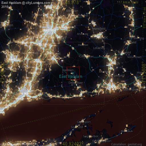
Analysis of East Haddam night lights 2016
Square area 10x10 km:
 0%
0%90-99
0%80-89
0%70-79
1.36%60-69
0.51%50-59
0.17%40-49
0%30-39
0.85%20-29
0.85%10-19
2.38%0-9
93.88%Square area 50x50 km:
0.82%90-99
1.25%80-89
1.94%70-79
2.21%60-69
2.32%50-59
2.58%40-49
2.41%30-39
2.61%20-29
3.8%10-19
7.74%0-9
72.32%Clear (daylight) street map image can be seen on geolist.org.
Map coordinates:
41° 58' 40.8" North, 73° 9' 51.6" West
41° 27' 11.3" North, 72° 27' 40.3" West
40° 55' 26.5" North, 71° 45' 29.1" West
Some cities around East Haddam sort by population:
• Middletown
19.9 km =12.4 mi,  307°
307°
• Guilford
25.9 km =16.1 mi,  225°
225°
• Montville Center
26 km =16.2 mi,  83°
83°
• Madison
22.4 km =13.9 mi,  210°
210°
• Cromwell
22 km =13.7 mi,  315°
315°
• Old Saybrook
19.3 km =12 mi,  158°
158°
• Hebron
24.1 km =15 mi,  19°
19°
• Portland
20 km =12.4 mi, 311°
4833363 (p: 9,042)
Sources (retrieved 2019-11-25):
» Earth at Night: Flat Maps 2012, 2016