Los Altos Hills night lights from space
Night Light of Los Altos Hills (California) from space (United States) Src. Average luminocity for 10x10km area is 52.9383% and for 50x50km: 36.165%.
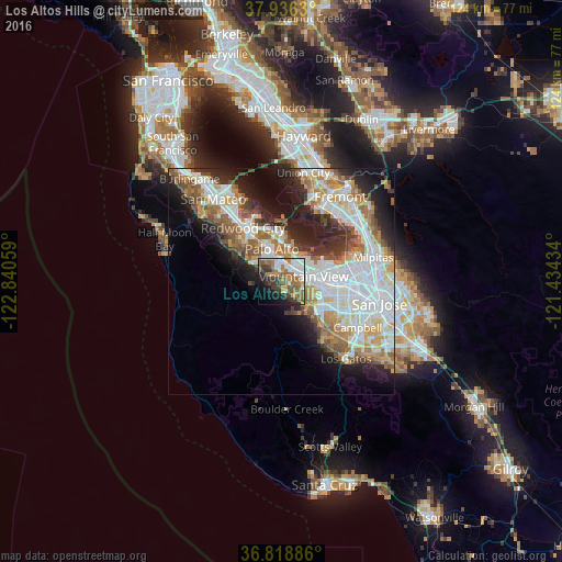
Analysis of Los Altos Hills night lights 2016
Square area 10x10 km:
 9.9%
9.9%90-99
12.5%80-89
0.97%70-79
5.68%60-69
15.1%50-59
10.88%40-49
5.84%30-39
9.58%20-29
9.09%10-19
12.5%0-9
7.95%Square area 50x50 km:
9.95%90-99
8.65%80-89
2.72%70-79
4.51%60-69
4.92%50-59
4.88%40-49
3.53%30-39
3.39%20-29
6.74%10-19
9.78%0-9
40.91%Clear (daylight) street map image can be seen on geolist.org.
Map coordinates:
37° 56' 10.7" North, 122° 50' 26.1" West
37° 22' 46.8" North, 122° 8' 14.9" West
36° 49' 7.9" North, 121° 26' 3.6" West
Some cities around Los Altos Hills sort by population:
• Sunnyvale
9 km =5.6 mi,  97°
97°
• Mountain View
4.8 km =3 mi,  81°
81°
• Palo Alto
6.9 km =4.3 mi,  355°
355°
• Cupertino
11.2 km =7 mi,  124°
124°
• Menlo Park
9.1 km =5.7 mi,  334°
334°
• East Palo Alto
9.9 km =6.2 mi, 358°
• Stanford
5.6 km =3.5 mi, 332°
• Atherton
10.5 km =6.5 mi, 329°
5368346 (p: 8,419)
Sources (retrieved 2019-11-25):
» Earth at Night: Flat Maps 2012, 2016