Stanford night lights from space
Night Light of Stanford (California) from space (United States) Src. Average luminocity for 10x10km area is 63.7744% and for 50x50km: 37.3351%.
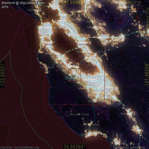
Analysis of Stanford night lights 2016
Square area 10x10 km:
 13.47%
90-99
13.31%80-89
1.95%70-79
9.9%60-69
19.48%50-59
16.4%40-49
4.38%30-39
5.68%20-29
7.63%10-19
7.31%0-9
0.49%Square area 50x50 km:
10.19%90-99
8.72%80-89
2.47%70-79
4.53%60-69
5.12%50-59
5.11%40-49
4.04%30-39
3.76%20-29
7.73%10-19
10.97%0-9
37.33%Clear (daylight) street map image can be seen on geolist.org.
Map coordinates:
37° 58' 49.5" North, 122° 52' 9.2" West
37° 25' 26.8" North, 122° 9' 57.9" West
36° 51' 49.1" North, 121° 27' 46.7" West
Some cities around Stanford sort by population:
• Palo Alto
2.8 km =1.7 mi,  45°
45°
• Menlo Park
3.6 km =2.2 mi,  336°
336°
• Los Altos
6.3 km =3.9 mi,  133°
133°
• East Palo Alto
5.4 km =3.4 mi,  23°
23°
• North Fair Oaks
6.2 km =3.9 mi,  334°
334°
• Los Altos Hills
5.6 km =3.5 mi,  152°
152°
• Atherton
5 km =3.1 mi, 325°
• Woodside
7.8 km =4.8 mi,  274°
274°
5398563 (p: 13,809)
Sources (retrieved 2019-11-25):
» Earth at Night: Flat Maps 2012, 2016