Los Altos night lights from space
Night Light of Los Altos (California) from space (United States) Src. Average luminocity for 10x10km area is 68.5341% and for 50x50km: 38.1788%.
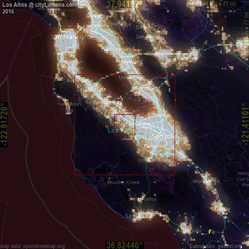

Analysis of Los Altos night lights 2016
Square area 10x10 km:
 18.51%
90-99
18.83%80-89
1.62%70-79
8.6%60-69
17.21%50-59
10.88%40-49
5.68%30-39
7.95%20-29
3.25%10-19
6.17%0-9
1.3%Square area 50x50 km:
10.51%90-99
9.33%80-89
2.82%70-79
4.93%60-69
5.19%50-59
5.01%40-49
3.6%30-39
3.49%20-29
6.93%10-19
10.14%0-9
38.06%Clear (daylight) street map image can be seen on geolist.org.
Map coordinates:
37° 56' 30.6" North, 122° 49' 2.1" West
37° 23' 6.8" North, 122° 6' 50.9" West
36° 49' 28.1" North, 121° 24' 39.6" West
Some cities around Los Altos sort by population:
• Sunnyvale
7.1 km =4.4 mi,  104°
104°
• Mountain View
2.7 km =1.7 mi,  88°
88°
• Palo Alto
6.8 km =4.2 mi,  337°
337°
• Cupertino
10 km =6.2 mi,  133°
133°
• Menlo Park
9.7 km =6 mi,  321°
321°
• East Palo Alto
9.6 km =6 mi,  345°
345°
• Stanford
6.3 km =3.9 mi,  313°
313°
• Atherton
11.2 km =7 mi, 318°
5368335 (p: 30,671)
Sources (retrieved 2019-11-25):
» Earth at Night: Flat Maps 2012, 2016