Lorton night lights from space
Night Light of Lorton (Virginia) from space (United States) Src. Average luminocity for 10x10km area is 72.7755% and for 50x50km: 56.0983%.
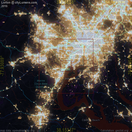
Analysis of Lorton night lights 2016
Square area 10x10 km:
 17.18%
90-99
15.14%80-89
10.2%70-79
16.67%60-69
14.46%50-59
7.65%40-49
5.61%30-39
7.48%20-29
4.93%10-19
0.68%0-9
0%Square area 50x50 km:
14.54%90-99
11.77%80-89
7.63%70-79
9.26%60-69
9.36%50-59
6%40-49
5.01%30-39
5.28%20-29
7.46%10-19
8.45%0-9
15.24%Clear (daylight) street map image can be seen on geolist.org.
Map coordinates:
39° 15' 3.2" North, 77° 55' 51.2" West
38° 42' 15.4" North, 77° 13' 39.9" West
38° 9' 12.5" North, 76° 31' 28.7" West
Some cities around Lorton sort by population:
• Lake Ridge
6.3 km =3.9 mi,  253°
253°
• Springfield
10.1 km =6.3 mi,  20°
20°
• West Springfield
7.6 km =4.7 mi,  4°
4°
• Woodlawn
8.4 km =5.2 mi,  80°
80°
• Newington
5.3 km =3.3 mi,  44°
44°
• Fort Belvoir
7.2 km =4.5 mi, 83°
• Laurel Hill
1.6 km =1 mi,  330°
330°
• Potomac Mills
8.7 km =5.4 mi,  221°
221°
4770714 (p: 18,610)
Sources (retrieved 2019-11-25):
» Earth at Night: Flat Maps 2012, 2016