Laurel Hill night lights from space
Night Light of Laurel Hill (Virginia) from space (United States) Src. Average luminocity for 10x10km area is 75.7228% and for 50x50km: 57.3632%.
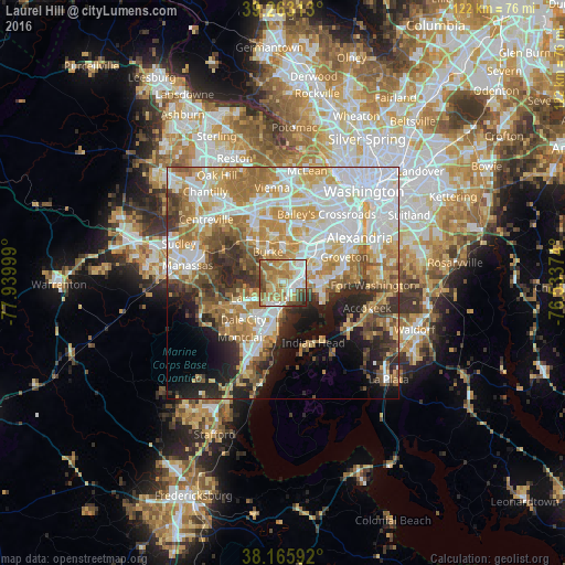
Analysis of Laurel Hill night lights 2016
Square area 10x10 km:
 15.65%
90-99
15.48%80-89
12.41%70-79
17.69%60-69
18.88%50-59
9.35%40-49
6.46%30-39
3.4%20-29
0.68%10-19
0%0-9
0%Square area 50x50 km:
15.25%90-99
12.16%80-89
7.57%70-79
9.67%60-69
9.42%50-59
5.95%40-49
5.03%30-39
5.19%20-29
7.29%10-19
8.24%0-9
14.22%Clear (daylight) street map image can be seen on geolist.org.
Map coordinates:
39° 15' 47.3" North, 77° 56' 24" West
38° 42' 59.9" North, 77° 14' 12.7" West
38° 9' 57.3" North, 76° 32' 1.5" West
Some cities around Laurel Hill sort by population:
• Lake Ridge
6.2 km =3.9 mi,  238°
238°
• Burke
9.1 km =5.7 mi,  340°
340°
• Springfield
9.2 km =5.7 mi,  28°
28°
• West Springfield
6.4 km =4 mi,  12°
12°
• Woodlawn
9 km =5.6 mi,  89°
89°
• Lorton
1.6 km =1 mi,  150°
150°
• Newington
5.1 km =3.2 mi,  61°
61°
• Fort Belvoir
7.9 km =4.9 mi, 93°
9670593 (p: 6,855)
Sources (retrieved 2019-11-25):
» Earth at Night: Flat Maps 2012, 2016