Fort Belvoir night lights from space
Night Light of Fort Belvoir (Virginia) from space (United States) Src. Average luminocity for 10x10km area is 67.4439% and for 50x50km: 60.0307%.
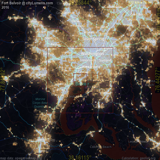
Analysis of Fort Belvoir night lights 2016
Square area 10x10 km:
 17.52%
90-99
16.16%80-89
8.33%70-79
10.54%60-69
9.01%50-59
8.5%40-49
5.27%30-39
7.99%20-29
13.78%10-19
2.89%0-9
0%Square area 50x50 km:
16.82%90-99
12.58%80-89
8.34%70-79
9.93%60-69
9.21%50-59
6.01%40-49
4.94%30-39
5.68%20-29
7.23%10-19
7.68%0-9
11.59%Clear (daylight) street map image can be seen on geolist.org.
Map coordinates:
39° 15' 30.4" North, 77° 50' 56.5" West
38° 42' 42.8" North, 77° 8' 45.2" West
38° 9' 40.1" North, 76° 26' 34" West
Some cities around Fort Belvoir sort by population:
• Woodlawn
1.3 km =0.8 mi,  64°
64°
• Lorton
7.2 km =4.5 mi,  263°
263°
• Franconia
7.8 km =4.8 mi,  359°
359°
• Hybla Valley
6.7 km =4.2 mi,  53°
53°
• Groveton
8.1 km =5 mi,  40°
40°
• Newington
4.5 km =2.8 mi,  311°
311°
• Mount Vernon
3.9 km =2.4 mi,  86°
86°
• Laurel Hill
7.9 km =4.9 mi,  273°
273°
7257902 (p: 7,100)
Sources (retrieved 2019-11-25):
» Earth at Night: Flat Maps 2012, 2016