Potomac Mills night lights from space
Night Light of Potomac Mills (Virginia) from space (United States) Src. Average luminocity for 10x10km area is 80.6997% and for 50x50km: 43.1324%.
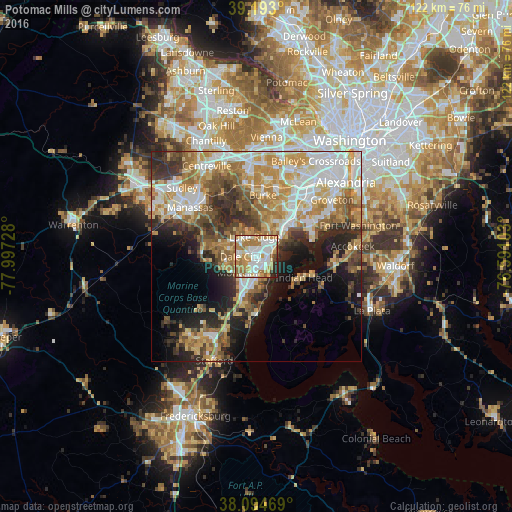
Analysis of Potomac Mills night lights 2016
Square area 10x10 km:
 22.24%
90-99
24.35%80-89
7.31%70-79
14.61%60-69
21.43%50-59
2.92%40-49
1.46%30-39
1.3%20-29
4.22%10-19
0.16%0-9
0%Square area 50x50 km:
8.89%90-99
8.17%80-89
5.84%70-79
7.77%60-69
7.27%50-59
5.57%40-49
4.82%30-39
5.41%20-29
8.28%10-19
9.37%0-9
28.6%Clear (daylight) street map image can be seen on geolist.org.
Map coordinates:
39° 11' 34.8" North, 77° 59' 50.2" West
38° 38' 45.4" North, 77° 17' 38.9" West
38° 5' 40.9" North, 76° 35' 27.7" West
Some cities around Potomac Mills sort by population:
• Dale City
1.8 km =1.1 mi,  236°
236°
• Lake Ridge
4.7 km =2.9 mi,  356°
356°
• Montclair
5.6 km =3.5 mi,  225°
225°
• Lorton
8.7 km =5.4 mi,  41°
41°
• Cherry Hill
8.8 km =5.5 mi,  164°
164°
• Triangle
11.6 km =7.2 mi,  198°
198°
• Laurel Hill
9.3 km =5.8 mi,  32°
32°
• Dumfries
9.2 km =5.7 mi, 198°
4780087 (p: 5,614)
Sources (retrieved 2019-11-25):
» Earth at Night: Flat Maps 2012, 2016