Lone Tree night lights from space
Night Light of Lone Tree (Colorado) from space (United States) Src. Average luminocity for 10x10km area is 79.8636% and for 50x50km: 46.0125%.
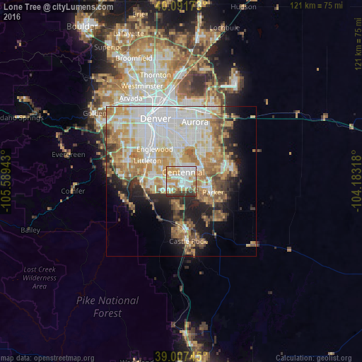
Analysis of Lone Tree night lights 2016
Square area 10x10 km:
 23.7%
23.7%90-99
24.68%80-89
7.47%70-79
19.97%60-69
5.36%50-59
4.38%40-49
3.57%30-39
10.23%20-29
0.65%10-19
0%0-9
0%Square area 50x50 km:
12.75%90-99
9.95%80-89
5.73%70-79
8.58%60-69
6.76%50-59
4.17%40-49
3.49%30-39
3.7%20-29
5.08%10-19
8.28%0-9
31.52%Clear (daylight) street map image can be seen on geolist.org.
Map coordinates:
40° 5' 30.2" North, 105° 35' 21.9" West
39° 33' 6.2" North, 104° 53' 10.7" West
39° 0' 26.8" North, 104° 10' 59.4" West
Some cities around Lone Tree sort by population:
• Centennial
3.2 km =2 mi,  14°
14°
• Highlands Ranch
7.1 km =4.4 mi,  271°
271°
• Southglenn
6.9 km =4.3 mi,  304°
304°
• Castlewood
3.9 km =2.4 mi,  340°
340°
• Greenwood Village
9.1 km =5.7 mi,  322°
322°
• Castle Pines North
8.9 km =5.5 mi,  184°
184°
• Stonegate
7.4 km =4.6 mi,  108°
108°
• Dove Valley
5.7 km =3.5 mi,  59°
59°
5429208 (p: 13,175)
Sources (retrieved 2019-11-25):
» Earth at Night: Flat Maps 2012, 2016