Stonegate night lights from space
Night Light of Stonegate (Colorado) from space (United States) Src. Average luminocity for 10x10km area is 66.2403% and for 50x50km: 38.0764%.
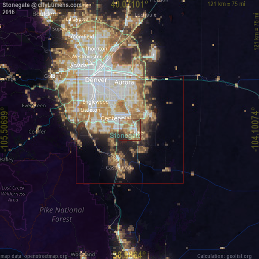
Analysis of Stonegate night lights 2016
Square area 10x10 km:
 9.9%
9.9%90-99
11.04%80-89
10.23%70-79
12.99%60-69
19.97%50-59
13.64%40-49
7.63%30-39
4.71%20-29
9.74%10-19
0.16%0-9
0%Square area 50x50 km:
10.16%90-99
8.48%80-89
4.75%70-79
6.98%60-69
5.33%50-59
3.61%40-49
2.94%30-39
3.24%20-29
4.45%10-19
7.67%0-9
42.39%Clear (daylight) street map image can be seen on geolist.org.
Map coordinates:
40° 4' 15.6" North, 105° 30' 25.2" West
39° 31' 51" North, 104° 48' 13.9" West
38° 59' 11" North, 104° 6' 2.7" West
Some cities around Stonegate sort by population:
• Centennial
8.3 km =5.2 mi,  310°
310°
• Parker
3.9 km =2.4 mi,  110°
110°
• Castlewood
10.3 km =6.4 mi, 305°
• Lone Tree
7.4 km =4.6 mi,  288°
288°
• Cherry Creek
13.4 km =8.3 mi,  329°
329°
• The Pinery
10.3 km =6.4 mi,  144°
144°
• Castle Pines North
10.2 km =6.3 mi,  229°
229°
• Dove Valley
5.7 km =3.5 mi,  337°
337°
5440437 (p: 8,962)
Sources (retrieved 2019-11-25):
» Earth at Night: Flat Maps 2012, 2016