Londontowne night lights from space
Night Light of Londontowne (Maryland) from space (United States) Src. Average luminocity for 10x10km area is 54.7551% and for 50x50km: 34.0122%.
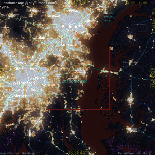
Analysis of Londontowne night lights 2016
Square area 10x10 km:
 5.95%
5.95%90-99
6.12%80-89
6.29%70-79
13.61%60-69
8.33%50-59
18.2%40-49
12.07%30-39
7.31%20-29
10.37%10-19
11.73%0-9
0%Square area 50x50 km:
4.35%90-99
5.33%80-89
4.94%70-79
6.78%60-69
6.35%50-59
7.18%40-49
5.67%30-39
5.82%20-29
4.02%10-19
6.77%0-9
42.79%Clear (daylight) street map image can be seen on geolist.org.
Map coordinates:
39° 28' 41.8" North, 77° 15' 9.1" West
38° 56' 0.4" North, 76° 32' 57.9" West
38° 23' 3.8" North, 75° 50' 46.6" West
Some cities around Londontowne sort by population:
• Annapolis
7.1 km =4.4 mi,  44°
44°
• Arnold
11.7 km =7.3 mi,  20°
20°
• Parole
5.4 km =3.4 mi, 17°
• Edgewater
2.6 km =1.6 mi,  358°
358°
• Mayo
6 km =3.7 mi,  147°
147°
• Davidsonville
6.9 km =4.3 mi,  260°
260°
• Shady Side
10.7 km =6.6 mi,  162°
162°
• Robinwood
3.8 km =2.4 mi,  52°
52°
4361094 (p: 8,018)
Sources (retrieved 2019-11-25):
» Earth at Night: Flat Maps 2012, 2016