Parole night lights from space
Night Light of Parole (Maryland) from space (United States) Src. Average luminocity for 10x10km area is 70.4334% and for 50x50km: 36.2574%.
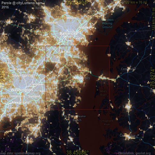
Analysis of Parole night lights 2016
Square area 10x10 km:
 13.8%
13.8%90-99
13.8%80-89
6.82%70-79
13.8%60-69
12.34%50-59
21.59%40-49
13.15%30-39
4.71%20-29
0%10-19
0%0-9
0%Square area 50x50 km:
5.71%90-99
6.78%80-89
5.07%70-79
6.57%60-69
6.12%50-59
6.83%40-49
5.55%30-39
5.93%20-29
3.97%10-19
6.71%0-9
40.75%Clear (daylight) street map image can be seen on geolist.org.
Map coordinates:
39° 31' 26.5" North, 77° 14' 1.1" West
38° 58' 46.4" North, 76° 31' 49.9" West
38° 25' 51.1" North, 75° 49' 38.6" West
Some cities around Parole sort by population:
• Annapolis
3.3 km =2.1 mi,  91°
91°
• Severna Park
10.2 km =6.3 mi,  352°
352°
• Arnold
6.3 km =3.9 mi,  22°
22°
• Edgewater
3 km =1.9 mi,  213°
213°
• Cape Saint Claire
10.2 km =6.3 mi,  46°
46°
• Mayo
10.3 km =6.4 mi,  171°
171°
• Londontowne
5.4 km =3.4 mi,  197°
197°
• Robinwood
3.1 km =1.9 mi,  154°
154°
4364964 (p: 15,922)
Sources (retrieved 2019-11-25):
» Earth at Night: Flat Maps 2012, 2016