Edgewater night lights from space
Night Light of Edgewater (Maryland) from space (United States) Src. Average luminocity for 10x10km area is 66.2987% and for 50x50km: 36.3292%.
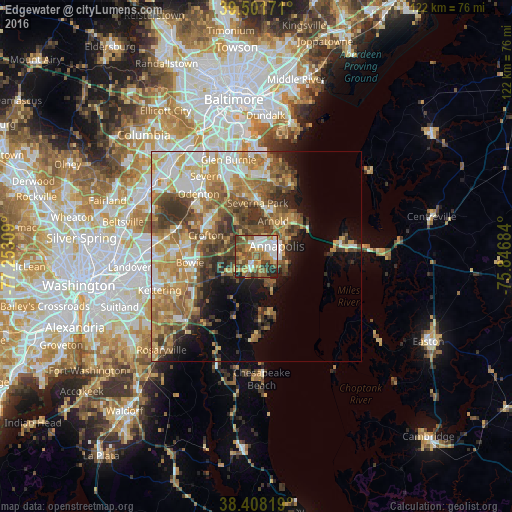
Analysis of Edgewater night lights 2016
Square area 10x10 km:
 11.69%
90-99
12.01%80-89
7.63%70-79
14.29%60-69
9.9%50-59
18.51%40-49
12.01%30-39
6.82%20-29
6.98%10-19
0.16%0-9
0%Square area 50x50 km:
5.23%90-99
6.25%80-89
5.35%70-79
7.04%60-69
6.53%50-59
7.26%40-49
5.62%30-39
5.72%20-29
3.92%10-19
6.64%0-9
40.45%Clear (daylight) street map image can be seen on geolist.org.
Map coordinates:
39° 30' 6.2" North, 77° 15' 11.1" West
38° 57' 25.4" North, 76° 32' 59.9" West
38° 24' 29.5" North, 75° 50' 48.6" West
Some cities around Edgewater sort by population:
• Annapolis
5.6 km =3.5 mi,  64°
64°
• Severna Park
12.6 km =7.8 mi,  1°
1°
• Arnold
9.3 km =5.8 mi,  26°
26°
• Parole
3 km =1.9 mi, 33°
• Mayo
8.4 km =5.2 mi,  156°
156°
• Londontowne
2.6 km =1.6 mi,  178°
178°
• Davidsonville
7.8 km =4.8 mi,  240°
240°
• Robinwood
3.1 km =1.9 mi,  95°
95°
4354072 (p: 9,023)
Sources (retrieved 2019-11-25):
» Earth at Night: Flat Maps 2012, 2016