Davidsonville night lights from space
Night Light of Davidsonville (Maryland) from space (United States) Src. Average luminocity for 10x10km area is 33.5068% and for 50x50km: 43.8653%.
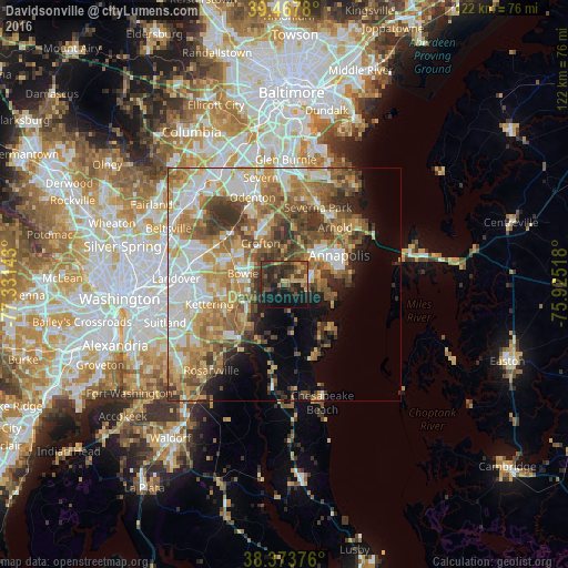
Analysis of Davidsonville night lights 2016
Square area 10x10 km:
 0%
0%90-99
0%80-89
4.25%70-79
6.63%60-69
3.06%50-59
7.99%40-49
11.22%30-39
15.31%20-29
18.03%10-19
27.21%0-9
6.29%Square area 50x50 km:
8.32%90-99
7.96%80-89
6.34%70-79
8.18%60-69
7.61%50-59
7.95%40-49
5.72%30-39
5.87%20-29
4%10-19
6.04%0-9
32.01%Clear (daylight) street map image can be seen on geolist.org.
Map coordinates:
39° 28' 4.1" North, 77° 19' 53.1" West
38° 55' 22.4" North, 76° 37' 41.9" West
38° 22' 25.5" North, 75° 55' 30.6" West
Some cities around Davidsonville sort by population:
• Bowie
9.1 km =5.7 mi,  284°
284°
• Crofton
10.2 km =6.3 mi,  329°
329°
• Parole
10.5 km =6.5 mi,  53°
53°
• Mitchellville
9.9 km =6.2 mi,  271°
271°
• Edgewater
7.8 km =4.8 mi,  60°
60°
• Mayo
10.8 km =6.7 mi,  111°
111°
• Londontowne
6.9 km =4.3 mi,  80°
80°
• Robinwood
10.4 km =6.5 mi,  70°
70°
4352815 (p: 8,000)
Sources (retrieved 2019-11-25):
» Earth at Night: Flat Maps 2012, 2016