Lincoln night lights from space
Night Light of Lincoln (Illinois) from space (United States) Src. Average luminocity for 10x10km area is 26.1542% and for 50x50km: 2.1899%.
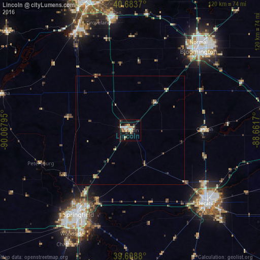
Analysis of Lincoln night lights 2016
Square area 10x10 km:
 3.08%
3.08%90-99
3.41%80-89
4.71%70-79
5.84%60-69
1.62%50-59
3.73%40-49
2.11%30-39
1.95%20-29
3.9%10-19
29.06%0-9
40.58%Square area 50x50 km:
0.13%90-99
0.17%80-89
0.48%70-79
0.4%60-69
0.21%50-59
0.34%40-49
0.28%30-39
0.27%20-29
0.42%10-19
1.44%0-9
95.86%Clear (daylight) street map image can be seen on geolist.org.
Map coordinates:
40° 41' 1.3" North, 90° 4' 4.6" West
40° 8' 54.2" North, 89° 21' 53.4" West
39° 36' 31.7" North, 88° 39' 42.1" West
Some cities around Lincoln sort by population:
• Springfield
45.3 km =28.1 mi,  211°
211°
• Bloomington
48.8 km =30.3 mi,  40°
40°
• Decatur
48.9 km =30.4 mi,  134°
134°
• Normal
51.6 km =32.1 mi, 37°
• Pekin
52.1 km =32.4 mi,  333°
333°
• Morton
52.3 km =32.5 mi,  351°
351°
• Clinton
34 km =21.1 mi,  89°
89°
• Creve Coeur
58.7 km =36.5 mi,  340°
340°
4899822 (p: 13,966)
Sources (retrieved 2019-11-25):
» Earth at Night: Flat Maps 2012, 2016