Creve Coeur night lights from space
Night Light of Creve Coeur (Illinois) from space (United States) Src. Average luminocity for 10x10km area is 65.8555% and for 50x50km: 18.741%.
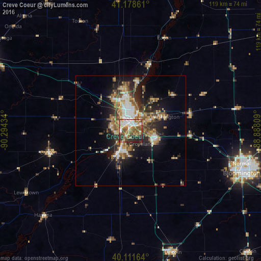
Analysis of Creve Coeur night lights 2016
Square area 10x10 km:
 11.2%
11.2%90-99
14.77%80-89
8.44%70-79
9.09%60-69
13.64%50-59
16.72%40-49
7.31%30-39
8.93%20-29
8.77%10-19
1.14%0-9
0%Square area 50x50 km:
2.24%90-99
2.93%80-89
2.73%70-79
2.36%60-69
3.02%50-59
3.32%40-49
2.95%30-39
3.22%20-29
5.39%10-19
9%0-9
62.84%Clear (daylight) street map image can be seen on geolist.org.
Map coordinates:
41° 10' 43" North, 90° 17' 39.6" West
40° 38' 50.1" North, 89° 35' 28.4" West
40° 6' 41.9" North, 88° 53' 17.1" West
Some cities around Creve Coeur sort by population:
• Peoria
5.2 km =3.2 mi,  2°
2°
• North Peoria
7.8 km =4.8 mi, 4°
• Pekin
9.8 km =6.1 mi,  205°
205°
• East Peoria
2.3 km =1.4 mi,  24°
24°
• Washington
16.7 km =10.4 mi,  67°
67°
• Morton
11.8 km =7.3 mi,  108°
108°
• Bartonville
5.1 km =3.2 mi,  273°
273°
• Peoria Heights
11.2 km =7 mi,  7°
7°
4889130 (p: 5,272)
Sources (retrieved 2019-11-25):
» Earth at Night: Flat Maps 2012, 2016