Kulpsville night lights from space
Night Light of Kulpsville (Pennsylvania) from space (United States) Src. Average luminocity for 10x10km area is 66.6494% and for 50x50km: 50.4186%.
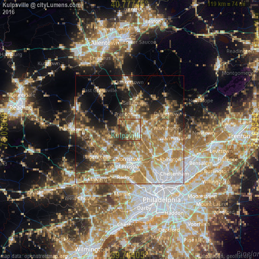
Analysis of Kulpsville night lights 2016
Square area 10x10 km:
 9.42%
9.42%90-99
12.18%80-89
8.6%70-79
13.96%60-69
17.37%50-59
13.64%40-49
9.09%30-39
11.04%20-29
4.71%10-19
0%0-9
0%Square area 50x50 km:
8.9%90-99
7.72%80-89
7.12%70-79
9.34%60-69
12.77%50-59
8.69%40-49
5.92%30-39
5.9%20-29
5.76%10-19
9.12%0-9
18.76%Clear (daylight) street map image can be seen on geolist.org.
Map coordinates:
40° 46' 38.8" North, 76° 2' 22.9" West
40° 14' 34.4" North, 75° 20' 11.6" West
39° 42' 14.6" North, 74° 38' 0.4" West
Some cities around Kulpsville sort by population:
• Lansdale
4.5 km =2.8 mi,  91°
91°
• West Norriton
13.1 km =8.1 mi,  195°
195°
• Montgomeryville
7.9 km =4.9 mi, 86°
• Harleysville
5.9 km =3.7 mi,  313°
313°
• Souderton
7.7 km =4.8 mi,  7°
7°
• Blue Bell
11.7 km =7.3 mi,  149°
149°
• Trooper
11.7 km =7.3 mi,  208°
208°
• Collegeville
11.7 km =7.3 mi,  236°
236°
5196605 (p: 8,194)
Sources (retrieved 2019-11-25):
» Earth at Night: Flat Maps 2012, 2016