Lehighton night lights from space
Night Light of Lehighton (Pennsylvania) from space (United States) Src. Average luminocity for 10x10km area is 20.6701% and for 50x50km: 11.0069%.
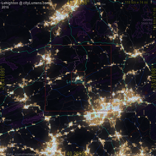
Analysis of Lehighton night lights 2016
Square area 10x10 km:
 1.7%
1.7%90-99
2.38%80-89
3.23%70-79
1.7%60-69
3.4%50-59
2.55%40-49
3.23%30-39
5.78%20-29
2.21%10-19
15.31%0-9
58.5%Square area 50x50 km:
1.19%90-99
1.3%80-89
1.37%70-79
1.42%60-69
1.57%50-59
1.56%40-49
1.8%30-39
2.76%20-29
3.09%10-19
6%0-9
77.94%Clear (daylight) street map image can be seen on geolist.org.
Map coordinates:
41° 21' 48.8" North, 76° 25' 0.9" West
40° 50' 1.3" North, 75° 42' 49.7" West
40° 17' 58.5" North, 75° 0' 38.4" West
Some cities around Lehighton sort by population:
• Allentown
31.3 km =19.4 mi,  143°
143°
• Whitehall Township
25.9 km =16.1 mi, 135°
• Hazleton
25.9 km =16.1 mi,  302°
302°
• Fullerton
30.2 km =18.8 mi, 137°
• Northampton
24.6 km =15.3 mi,  131°
131°
• Tamaqua
21.9 km =13.6 mi,  259°
259°
• Catasauqua
28.3 km =17.6 mi, 134°
• Palmerton
9.3 km =5.8 mi,  112°
112°
5197673 (p: 5,314)
Sources (retrieved 2019-11-25):
» Earth at Night: Flat Maps 2012, 2016