Northampton night lights from space
Night Light of Northampton (Pennsylvania) from space (United States) Src. Average luminocity for 10x10km area is 49.3312% and for 50x50km: 27.106%.
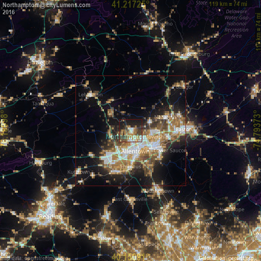
Analysis of Northampton night lights 2016
Square area 10x10 km:
 6.66%
6.66%90-99
7.47%80-89
5.52%70-79
9.09%60-69
10.88%50-59
5.68%40-49
9.25%30-39
11.85%20-29
9.9%10-19
23.05%0-9
0.65%Square area 50x50 km:
4.25%90-99
4.3%80-89
2.88%70-79
3.53%60-69
4.93%50-59
4.53%40-49
4%30-39
4.83%20-29
5.83%10-19
13.18%0-9
47.72%Clear (daylight) street map image can be seen on geolist.org.
Map coordinates:
41° 13' 2.1" North, 76° 11' 59.9" West
40° 41' 10.4" North, 75° 29' 48.7" West
40° 9' 3.3" North, 74° 47' 37.4" West
Some cities around Northampton sort by population:
• Allentown
8.7 km =5.4 mi,  176°
176°
• Bethlehem
12.6 km =7.8 mi,  122°
122°
• Whitehall Township
2.2 km =1.4 mi,  186°
186°
• Fullerton
6.4 km =4 mi,  161°
161°
• Middletown
14.6 km =9.1 mi,  108°
108°
• Catasauqua
4 km =2.5 mi,  151°
151°
• Wescosville
14.1 km =8.8 mi,  199°
199°
• Palmerton
16.1 km =10 mi,  322°
322°
5203804 (p: 9,860)
Sources (retrieved 2019-11-25):
» Earth at Night: Flat Maps 2012, 2016