Tamaqua night lights from space
Night Light of Tamaqua (Pennsylvania) from space (United States) Src. Average luminocity for 10x10km area is 13.5816% and for 50x50km: 10.3632%.
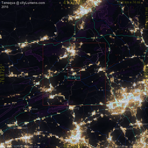
Analysis of Tamaqua night lights 2016
Square area 10x10 km:
 0.85%
0.85%90-99
0.51%80-89
1.53%70-79
3.91%60-69
1.02%50-59
2.89%40-49
2.04%30-39
2.72%20-29
0.68%10-19
2.55%0-9
81.29%Square area 50x50 km:
0.93%90-99
1.12%80-89
1.25%70-79
1.31%60-69
1.09%50-59
1.68%40-49
1.32%30-39
2.12%20-29
3.11%10-19
9.08%0-9
77%Clear (daylight) street map image can be seen on geolist.org.
Map coordinates:
41° 19' 38.9" North, 76° 40' 21" West
40° 47' 50.3" North, 75° 58' 9.7" West
40° 15' 46.4" North, 75° 15' 58.5" West
Some cities around Tamaqua sort by population:
• Hazleton
17.9 km =11.1 mi,  358°
358°
• Pottsville
22.7 km =14.1 mi,  236°
236°
• Berwick
36.2 km =22.5 mi,  322°
322°
• Mount Carmel
37.2 km =23.1 mi,  269°
269°
• Lehighton
21.9 km =13.6 mi,  79°
79°
• Palmerton
30.1 km =18.7 mi,  89°
89°
• Schuylkill Haven
25.1 km =15.6 mi,  222°
222°
• Kutztown
35.1 km =21.8 mi,  152°
152°
5215142 (p: 6,829)
Sources (retrieved 2019-11-25):
» Earth at Night: Flat Maps 2012, 2016