Catasauqua night lights from space
Night Light of Catasauqua (Pennsylvania) from space (United States) Src. Average luminocity for 10x10km area is 74.3409% and for 50x50km: 28.1041%.
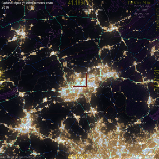
Analysis of Catasauqua night lights 2016
Square area 10x10 km:
 20.13%
90-99
19.48%80-89
8.6%70-79
9.74%60-69
13.15%50-59
8.44%40-49
7.47%30-39
9.25%20-29
3.73%10-19
0%0-9
0%Square area 50x50 km:
4.48%90-99
4.41%80-89
2.9%70-79
3.66%60-69
5.2%50-59
4.65%40-49
4.17%30-39
4.98%20-29
6.2%10-19
13.62%0-9
45.74%Clear (daylight) street map image can be seen on geolist.org.
Map coordinates:
41° 11' 10" North, 76° 10' 39.9" West
40° 39' 17.4" North, 75° 28' 28.7" West
40° 7' 9.4" North, 74° 46' 17.4" West
Some cities around Catasauqua sort by population:
• Allentown
5.3 km =3.3 mi,  194°
194°
• Bethlehem
9.4 km =5.8 mi,  110°
110°
• Whitehall Township
2.5 km =1.6 mi,  301°
301°
• Fullerton
2.6 km =1.6 mi,  177°
177°
• Emmaus
13 km =8.1 mi, 188°
• Northampton
4 km =2.5 mi,  331°
331°
• Middletown
12.1 km =7.5 mi,  95°
95°
• Wescosville
11.8 km =7.3 mi,  214°
214°
5183438 (p: 6,525)
Sources (retrieved 2019-11-25):
» Earth at Night: Flat Maps 2012, 2016