Pineville night lights from space
Night Light of Pineville (North Carolina) from space (United States) Src. Average luminocity for 10x10km area is 91.3059% and for 50x50km: 67.9531%.
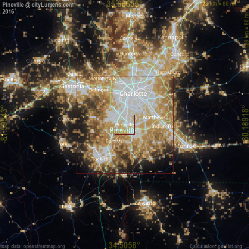
Analysis of Pineville night lights 2016
Square area 10x10 km:
 31.82%
90-99
31.12%80-89
19.23%70-79
14.86%60-69
2.27%50-59
0.7%40-49
0%30-39
0%20-29
0%10-19
0%0-9
0%Square area 50x50 km:
16.28%90-99
13.87%80-89
13.15%70-79
12.96%60-69
12.13%50-59
6.33%40-49
5.44%30-39
4.72%20-29
4.68%10-19
5.98%0-9
4.46%Clear (daylight) street map image can be seen on geolist.org.
Map coordinates:
35° 39' 23.6" North, 81° 35' 43.5" West
35° 4' 59.5" North, 80° 53' 32.3" West
34° 30' 20.9" North, 80° 11' 21" West
Some cities around Pineville sort by population:
• Charlotte
16.6 km =10.3 mi,  15°
15°
• Matthews
15.8 km =9.8 mi,  76°
76°
• Stallings
18.8 km =11.7 mi,  87°
87°
• Fort Mill
9.7 km =6 mi,  209°
209°
• Weddington
13.7 km =8.5 mi,  119°
119°
• Tega Cay
14 km =8.7 mi,  242°
242°
• Lake Wylie
14 km =8.7 mi,  281°
281°
• Marvin
12.4 km =7.7 mi,  145°
145°
4485305 (p: 8,429)
Sources (retrieved 2019-11-25):
» Earth at Night: Flat Maps 2012, 2016