Belmont night lights from space
Night Light of Belmont (North Carolina) from space (United States) Src. Average luminocity for 10x10km area is 74.7815% and for 50x50km: 61.6113%.
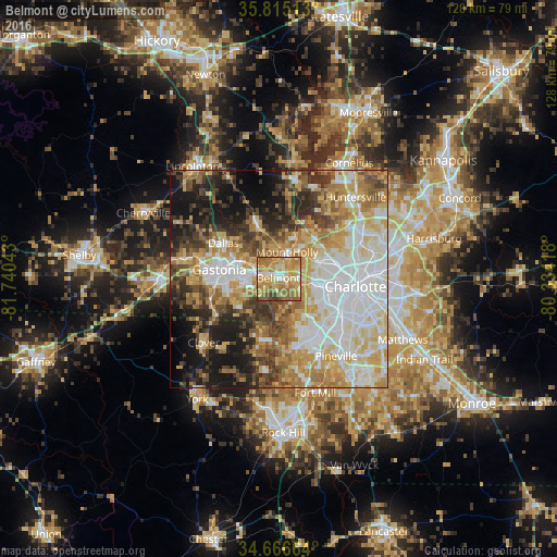
Analysis of Belmont night lights 2016
Square area 10x10 km:
 6.64%
6.64%90-99
9.79%80-89
23.95%70-79
22.2%60-69
23.95%50-59
9.09%40-49
1.92%30-39
2.45%20-29
0%10-19
0%0-9
0%Square area 50x50 km:
14.63%90-99
12.41%80-89
11.33%70-79
9.92%60-69
8.96%50-59
5.83%40-49
6.38%30-39
7.29%20-29
7.48%10-19
11.5%0-9
4.27%Clear (daylight) street map image can be seen on geolist.org.
Map coordinates:
35° 48' 54.5" North, 81° 44' 25.5" West
35° 14' 34.5" North, 81° 2' 14.3" West
34° 39' 59.9" North, 80° 20' 3" West
Some cities around Belmont sort by population:
• Charlotte
17.7 km =11 mi,  95°
95°
• Gastonia
13.8 km =8.6 mi,  278°
278°
• Mount Holly
6.4 km =4 mi,  17°
17°
• Lake Wylie
15 km =9.3 mi,  181°
181°
• Pineville
22.1 km =13.7 mi,  143°
143°
• Clover
22.6 km =14 mi,  229°
229°
• Bessemer City
22.9 km =14.2 mi, 281°
• South Gastonia
15.5 km =9.6 mi,  260°
260°
4454860 (p: 10,533)
Sources (retrieved 2019-11-25):
» Earth at Night: Flat Maps 2012, 2016