Adelanto night lights from space
Night Light of Adelanto (California) from space (United States) Src. Average luminocity for 10x10km area is 38.9895% and for 50x50km: 14.2643%.
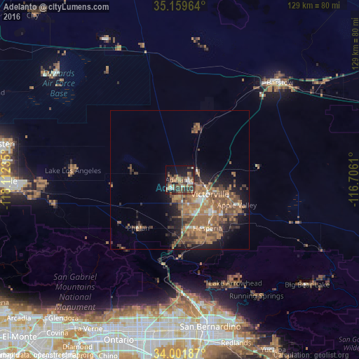

Analysis of Adelanto night lights 2016
Square area 10x10 km:
 3.5%
3.5%90-99
4.9%80-89
2.45%70-79
2.62%60-69
10.14%50-59
10.31%40-49
10.49%30-39
12.41%20-29
7.17%10-19
22.73%0-9
13.29%Square area 50x50 km:
0.8%90-99
1.16%80-89
0.52%70-79
1.59%60-69
5.6%50-59
4.49%40-49
3.82%30-39
2.38%20-29
2.47%10-19
6.37%0-9
70.81%Clear (daylight) street map image can be seen on geolist.org.
Map coordinates:
35° 9' 34.7" North, 118° 6' 44.5" West
34° 34' 58" North, 117° 24' 33.2" West
34° 0' 6.7" North, 116° 42' 22" West
Some cities around Adelanto sort by population:
• Victorville
12 km =7.5 mi,  115°
115°
• Hesperia
20 km =12.4 mi,  150°
150°
• Apple Valley
22.4 km =13.9 mi,  114°
114°
• Phelan
22.9 km =14.2 mi,  220°
220°
• Oak Hills
22.3 km =13.9 mi,  173°
173°
• Spring Valley Lake
16.3 km =10.1 mi,  127°
127°
• Piñon Hills
27.4 km =17 mi,  232°
232°
• Silver Lakes
19.1 km =11.9 mi,  19°
19°
5322400 (p: 33,166)
Sources (retrieved 2019-11-25):
» Earth at Night: Flat Maps 2012, 2016