Wildwood night lights from space
Night Light of Wildwood (Florida) from space (United States) Src. Average luminocity for 10x10km area is 57.9811% and for 50x50km: 26.401%.
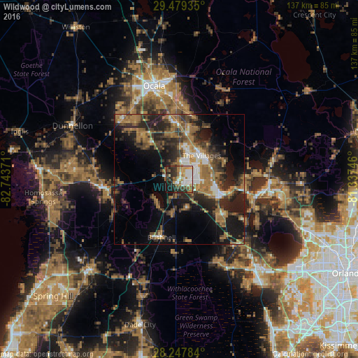
Analysis of Wildwood night lights 2016
Square area 10x10 km:
 12.31%
90-99
12.12%80-89
4.55%70-79
8.33%60-69
12.69%50-59
7.2%40-49
5.3%30-39
10.04%20-29
17.61%10-19
9.47%0-9
0.38%Square area 50x50 km:
2.72%90-99
2.89%80-89
1.23%70-79
2.34%60-69
9.71%50-59
4.27%40-49
4.57%30-39
6.21%20-29
9.32%10-19
14.21%0-9
42.54%Clear (daylight) street map image can be seen on geolist.org.
Map coordinates:
29° 28' 45.7" North, 82° 44' 37.4" West
28° 51' 55.5" North, 82° 2' 26.1" West
28° 14' 52.2" North, 81° 20' 14.9" West
Some cities around Wildwood sort by population:
• The Villages
10.9 km =6.8 mi,  45°
45°
• Leesburg
17 km =10.6 mi,  110°
110°
• Tavares
31.4 km =19.5 mi,  102°
102°
• Lady Lake
12.8 km =8 mi,  63°
63°
• Inverness
28.4 km =17.6 mi,  263°
263°
• Inverness Highlands South
29.8 km =18.5 mi, 255°
• Silver Springs Shores
26.6 km =16.5 mi,  4°
4°
• Floral City
28.1 km =17.5 mi,  242°
242°
4178292 (p: 6,590)
Sources (retrieved 2019-11-25):
» Earth at Night: Flat Maps 2012, 2016