Kings Point night lights from space
Night Light of Kings Point (Florida) from space (United States) Src. Average luminocity for 10x10km area is 95.0455% and for 50x50km: 41.6685%.
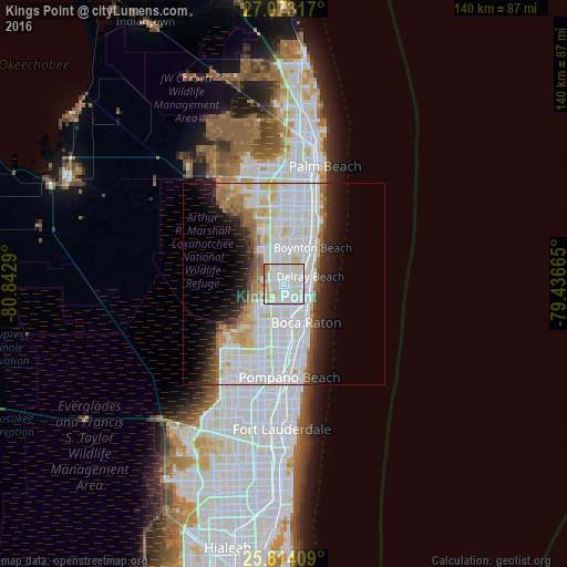
Analysis of Kings Point night lights 2016
Square area 10x10 km:
 39.77%
90-99
43.18%80-89
8.9%70-79
4.92%60-69
3.22%50-59
0%40-49
0%30-39
0%20-29
0%10-19
0%0-9
0%Square area 50x50 km:
15.25%90-99
13.85%80-89
3.97%70-79
2.18%60-69
3.7%50-59
2.35%40-49
2.08%30-39
2.34%20-29
4.63%10-19
6.92%0-9
42.71%Clear (daylight) street map image can be seen on geolist.org.
Map coordinates:
27° 4' 23.4" North, 80° 50' 34.4" West
26° 26' 43.3" North, 80° 8' 23.2" West
25° 48' 50.7" North, 79° 26' 11.9" West
Some cities around Kings Point sort by population:
• Boca Raton
11.2 km =7 mi,  149°
149°
• Deerfield Beach
14.7 km =9.1 mi,  164°
164°
• Boynton Beach
11.5 km =7.1 mi,  39°
39°
• Delray Beach
6.9 km =4.3 mi,  74°
74°
• Parkland
17.9 km =11.1 mi,  212°
212°
• Boca Del Mar
11.2 km =7 mi,  183°
183°
• Sandalfoot Cove
12.8 km =8 mi,  201°
201°
• Lantana
18 km =11.2 mi,  29°
29°
4160932 (p: 12,201)
Sources (retrieved 2019-11-25):
» Earth at Night: Flat Maps 2012, 2016