Ken Caryl night lights from space
Night Light of Ken Caryl (Colorado) from space (United States) Src. Average luminocity for 10x10km area is 54.3718% and for 50x50km: 39.3373%.
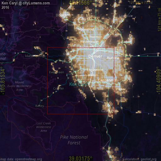

Analysis of Ken Caryl night lights 2016
Square area 10x10 km:
 4.55%
4.55%90-99
5.84%80-89
7.79%70-79
10.71%60-69
19.16%50-59
10.71%40-49
6.33%30-39
10.71%20-29
13.96%10-19
7.95%0-9
2.27%Square area 50x50 km:
13.17%90-99
8.99%80-89
4.46%70-79
6.41%60-69
4.55%50-59
2.88%40-49
2.22%30-39
3.27%20-29
3.84%10-19
5.67%0-9
44.54%Clear (daylight) street map image can be seen on geolist.org.
Map coordinates:
40° 6' 56.4" North, 105° 48' 55.2" West
39° 34' 33" North, 105° 6' 44" West
39° 1' 54.3" North, 104° 24' 32.7" West
Some cities around Ken Caryl sort by population:
• Lakewood
14.6 km =9.1 mi,  10°
10°
• Highlands Ranch
12.5 km =7.8 mi,  101°
101°
• Littleton
9.2 km =5.7 mi,  63°
63°
• Southglenn
13.7 km =8.5 mi,  84°
84°
• Englewood
13.3 km =8.3 mi,  53°
53°
• Columbine
3.9 km =2.4 mi,  70°
70°
• Roxborough Park
11.6 km =7.2 mi,  168°
168°
• Sheridan
10.9 km =6.8 mi,  43°
43°
5427207 (p: 32,438)
Sources (retrieved 2019-11-25):
» Earth at Night: Flat Maps 2012, 2016