Jacksonville night lights from space
Night Light of Jacksonville (Illinois) from space (United States) Src. Average luminocity for 10x10km area is 38.2175% and for 50x50km: 2.7424%.
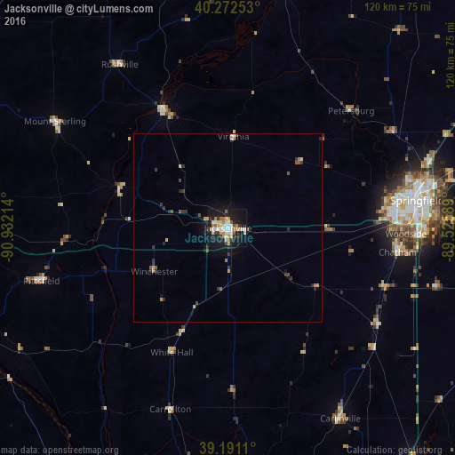
Analysis of Jacksonville night lights 2016
Square area 10x10 km:
 5.03%
5.03%90-99
8.6%80-89
6.49%70-79
5.19%60-69
5.19%50-59
3.25%40-49
1.46%30-39
4.55%20-29
5.36%10-19
42.53%0-9
12.34%Square area 50x50 km:
0.21%90-99
0.39%80-89
0.43%70-79
0.36%60-69
0.34%50-59
0.32%40-49
0.25%30-39
0.64%20-29
0.56%10-19
2.31%0-9
94.19%Clear (daylight) street map image can be seen on geolist.org.
Map coordinates:
40° 16' 21.1" North, 90° 55' 55.7" West
39° 44' 2.2" North, 90° 13' 44.4" West
39° 11' 28" North, 89° 31' 33.2" West
Some cities around Jacksonville sort by population:
• Springfield
50.6 km =31.4 mi,  81°
81°
• Godfrey
86.6 km =53.8 mi,  177°
177°
• Chatham
45.3 km =28.1 mi,  98°
98°
• Taylorville
82.6 km =51.3 mi, 104°
• Jerseyville
68.8 km =42.8 mi,  187°
187°
• Litchfield
79.3 km =49.3 mi,  141°
141°
• Beardstown
35.7 km =22.2 mi,  332°
332°
• Carlinville
58.6 km =36.4 mi,  149°
149°
4241704 (p: 19,103)
Sources (retrieved 2019-11-25):
» Earth at Night: Flat Maps 2012, 2016