Chatham night lights from space
Night Light of Chatham (Illinois) from space (United States) Src. Average luminocity for 10x10km area is 27.5958% and for 50x50km: 12.0102%.
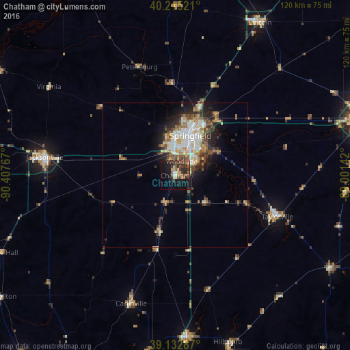
Analysis of Chatham night lights 2016
Square area 10x10 km:
 1.3%
1.3%90-99
1.3%80-89
4.71%70-79
2.44%60-69
3.9%50-59
4.38%40-49
10.55%30-39
6.82%20-29
8.93%10-19
25.81%0-9
29.87%Square area 50x50 km:
2.11%90-99
2.02%80-89
1.49%70-79
1.51%60-69
1.69%50-59
1.61%40-49
1.98%30-39
1.67%20-29
3.1%10-19
5.01%0-9
77.81%Clear (daylight) street map image can be seen on geolist.org.
Map coordinates:
40° 12' 54.8" North, 90° 24' 27.6" West
39° 40' 34.2" North, 89° 42' 16.3" West
39° 7' 58.3" North, 89° 0' 5.1" West
Some cities around Chatham sort by population:
• Springfield
14.9 km =9.3 mi,  20°
20°
• Jacksonville
45.3 km =28.1 mi,  278°
278°
• Lincoln
60 km =37.3 mi,  28°
28°
• Taylorville
37.9 km =23.5 mi,  111°
111°
• Litchfield
55.9 km =34.7 mi,  175°
175°
• Hillsboro
60 km =37.3 mi,  162°
162°
• Carlinville
46.6 km =29 mi,  199°
199°
• Pana
62.4 km =38.8 mi,  120°
120°
4235683 (p: 12,351)
Sources (retrieved 2019-11-25):
» Earth at Night: Flat Maps 2012, 2016