Godfrey night lights from space
Night Light of Godfrey (Illinois) from space (United States) Src. Average luminocity for 10x10km area is 41.4838% and for 50x50km: 26.8939%.
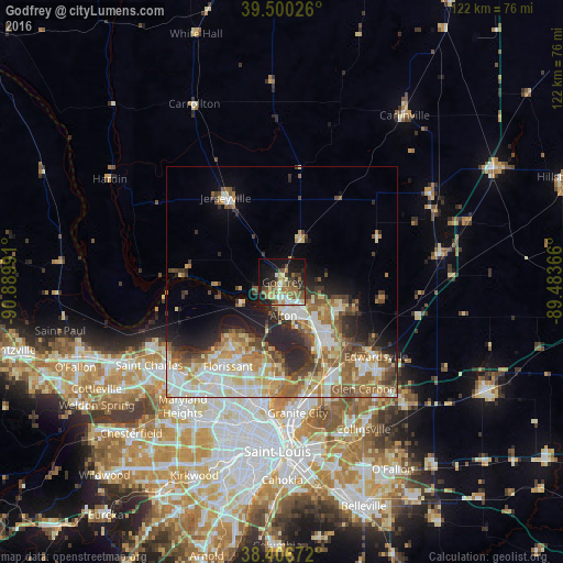
Analysis of Godfrey night lights 2016
Square area 10x10 km:
 5.03%
5.03%90-99
5.03%80-89
6.33%70-79
5.03%60-69
11.04%50-59
6.82%40-49
5.68%30-39
6.01%20-29
11.04%10-19
25.65%0-9
12.34%Square area 50x50 km:
4.6%90-99
5.44%80-89
4.29%70-79
3.34%60-69
4.74%50-59
4.23%40-49
3.4%30-39
3.14%20-29
5.57%10-19
6.27%0-9
54.99%Clear (daylight) street map image can be seen on geolist.org.
Map coordinates:
39° 30' 0.9" North, 90° 53' 23.7" West
38° 57' 20.2" North, 90° 11' 12.4" West
38° 24' 24.2" North, 89° 29' 1.2" West
Some cities around Godfrey sort by population:
• Upper Alton
5.8 km =3.6 mi,  147°
147°
• Alton
7.2 km =4.5 mi,  178°
178°
• Spanish Lake
18.8 km =11.7 mi,  187°
187°
• Old Jamestown
15.9 km =9.9 mi,  212°
212°
• Wood River
13 km =8.1 mi,  143°
143°
• Bethalto
13.7 km =8.5 mi,  112°
112°
• Black Jack
19.3 km =12 mi,  201°
201°
• East Alton
10.6 km =6.6 mi, 142°
4239509 (p: 17,759)
Sources (retrieved 2019-11-25):
» Earth at Night: Flat Maps 2012, 2016