Iowa Park night lights from space
Night Light of Iowa Park (Texas) from space (United States) Src. Average luminocity for 10x10km area is 12.035% and for 50x50km: 8.7469%.
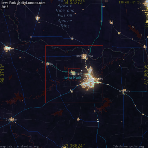
Analysis of Iowa Park night lights 2016
Square area 10x10 km:
 0%
0%90-99
0%80-89
3.67%70-79
1.92%60-69
0.7%50-59
2.8%40-49
1.4%30-39
3.5%20-29
0.7%10-19
1.05%0-9
84.27%Square area 50x50 km:
1.01%90-99
1.2%80-89
1.48%70-79
1.22%60-69
1.4%50-59
1.42%40-49
0.95%30-39
1.26%20-29
2.17%10-19
4.7%0-9
83.19%Clear (daylight) street map image can be seen on geolist.org.
Map coordinates:
34° 31' 57.8" North, 99° 22' 18.5" West
33° 57' 5.3" North, 98° 40' 7.2" West
33° 21' 58.5" North, 97° 57' 56" West
Some cities around Iowa Park sort by population:
• Wichita Falls
16.7 km =10.4 mi,  104°
104°
• Lawton
77.4 km =48.1 mi,  19°
19°
• Duncan
89.6 km =55.7 mi,  46°
46°
• Altus
97.8 km =60.8 mi,  321°
321°
• Burkburnett
18.6 km =11.6 mi,  29°
29°
• Vernon
59.5 km =37 mi,  292°
292°
• Graham
94.2 km =58.5 mi,  175°
175°
• Bowie
87.5 km =54.4 mi,  119°
119°
4700122 (p: 6,344)
Sources (retrieved 2019-11-25):
» Earth at Night: Flat Maps 2012, 2016