Vermilion-on-the-Lake night lights from space
Night Light of Vermilion-on-the-Lake (Ohio) from space (United States) Src. Average luminocity for 10x10km area is 28.1752% and for 50x50km: 17.0494%.
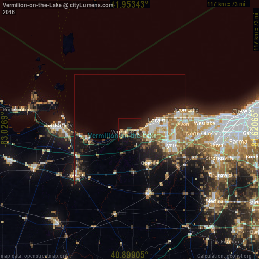
Analysis of Vermilion-on-the-Lake night lights 2016
Square area 10x10 km:
 0.85%
0.85%90-99
2.38%80-89
7.31%70-79
3.74%60-69
3.74%50-59
3.23%40-49
2.72%30-39
8.16%20-29
8.5%10-19
31.97%0-9
27.38%Square area 50x50 km:
1.98%90-99
3.47%80-89
2.43%70-79
1.76%60-69
3.54%50-59
2.23%40-49
1.93%30-39
2.36%20-29
4.31%10-19
9.39%0-9
66.6%Clear (daylight) street map image can be seen on geolist.org.
Map coordinates:
41° 57' 12.3" North, 83° 1' 36.8" West
41° 25' 42.2" North, 82° 19' 25.6" West
40° 53' 56.6" North, 81° 37' 14.3" West
Some cities around Vermilion-on-the-Lake sort by population:
• Lorain
12.1 km =7.5 mi,  77°
77°
• Elyria
19.2 km =11.9 mi,  110°
110°
• Avon
24.2 km =15 mi, 83°
• Avon Center
25.6 km =15.9 mi, 82°
• Amherst
9.1 km =5.7 mi, 111°
• Sheffield Lake
19.7 km =12.2 mi,  70°
70°
• Oberlin
17.4 km =10.8 mi,  149°
149°
• Huron
19.6 km =12.2 mi,  259°
259°
5175080 (p: 11,006)
Sources (retrieved 2019-11-25):
» Earth at Night: Flat Maps 2012, 2016