Boonville night lights from space
Night Light of Boonville (Indiana) from space (United States) Src. Average luminocity for 10x10km area is 18.5032% and for 50x50km: 12.763%.
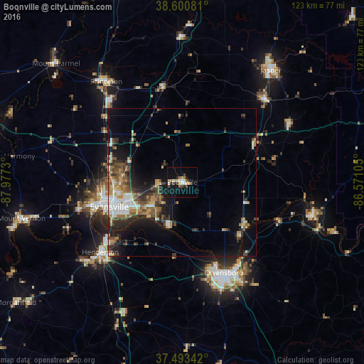
Analysis of Boonville night lights 2016
Square area 10x10 km:
 1.95%
1.95%90-99
2.6%80-89
3.25%70-79
0.97%60-69
1.62%50-59
3.41%40-49
2.44%30-39
0.81%20-29
2.44%10-19
21.92%0-9
58.6%Square area 50x50 km:
1.7%90-99
1.79%80-89
1.34%70-79
1.57%60-69
1.74%50-59
2.26%40-49
2.12%30-39
2.35%20-29
3.27%10-19
7.37%0-9
74.49%Clear (daylight) street map image can be seen on geolist.org.
Map coordinates:
38° 36' 2.9" North, 87° 58' 38.3" West
38° 2' 57.2" North, 87° 16' 27" West
37° 29' 36.3" North, 86° 34' 15.8" West
Some cities around Boonville sort by population:
• Evansville
26 km =16.2 mi,  251°
251°
• Owensboro
33.7 km =20.9 mi,  155°
155°
• Henderson
36.4 km =22.6 mi,  229°
229°
• Jasper
48.4 km =30.1 mi,  38°
38°
• Princeton
42.6 km =26.5 mi,  323°
323°
• Tell City
45.7 km =28.4 mi,  103°
103°
• Knottsville
44.8 km =27.8 mi,  133°
133°
• Huntingburg
39.4 km =24.5 mi,  45°
45°
4254797 (p: 6,180)
Sources (retrieved 2019-11-25):
» Earth at Night: Flat Maps 2012, 2016