Hueytown night lights from space
Night Light of Hueytown (Alabama) from space (United States) Src. Average luminocity for 10x10km area is 67.0087% and for 50x50km: 39.185%.
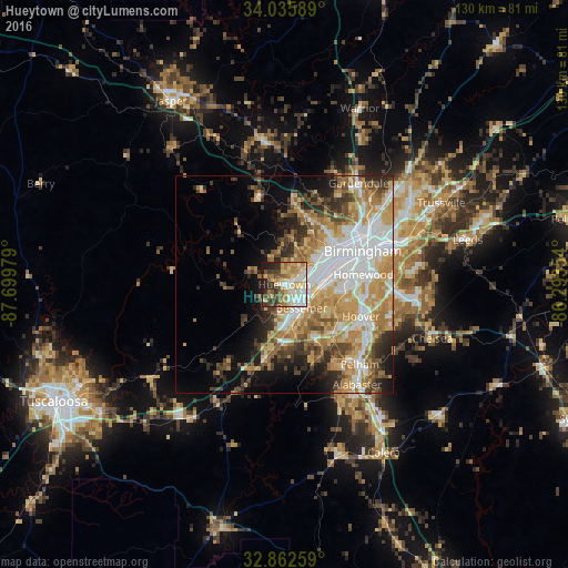
Analysis of Hueytown night lights 2016
Square area 10x10 km:
 11.36%
90-99
15.73%80-89
14.34%70-79
11.71%60-69
11.54%50-59
5.42%40-49
7.87%30-39
9.09%20-29
8.39%10-19
4.55%0-9
0%Square area 50x50 km:
9.04%90-99
6.67%80-89
5.77%70-79
7.69%60-69
6.78%50-59
3.78%40-49
4.38%30-39
4.79%20-29
5.17%10-19
7.46%0-9
38.47%Clear (daylight) street map image can be seen on geolist.org.
Map coordinates:
34° 2' 9.2" North, 87° 41' 59.2" West
33° 27' 4.4" North, 86° 59' 48" West
32° 51' 45.3" North, 86° 17' 36.7" West
Some cities around Hueytown sort by population:
• Hoover
17.9 km =11.1 mi,  106°
106°
• Vestavia Hills
19.4 km =12.1 mi,  90°
90°
• Bessemer
6.8 km =4.2 mi,  144°
144°
• Homewood
18.3 km =11.4 mi,  82°
82°
• Fairfield
8.8 km =5.5 mi,  63°
63°
• Pleasant Grove
5 km =3.1 mi,  28°
28°
• Forestdale
16.2 km =10.1 mi,  35°
35°
• Midfield
8.2 km =5.1 mi, 82°
4068446 (p: 15,710)
Sources (retrieved 2019-11-25):
» Earth at Night: Flat Maps 2012, 2016