Forestdale night lights from space
Night Light of Forestdale (Alabama) from space (United States) Src. Average luminocity for 10x10km area is 65.8407% and for 50x50km: 45.0921%.
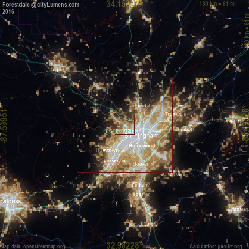
Analysis of Forestdale night lights 2016
Square area 10x10 km:
 9.52%
9.52%90-99
9.16%80-89
12.82%70-79
15.02%60-69
14.29%50-59
11.36%40-49
11.9%30-39
9.52%20-29
6.41%10-19
0%0-9
0%Square area 50x50 km:
9.8%90-99
7.66%80-89
7.28%70-79
8.85%60-69
8.38%50-59
4.27%40-49
4.49%30-39
5.12%20-29
5.72%10-19
9.55%0-9
28.89%Clear (daylight) street map image can be seen on geolist.org.
Map coordinates:
34° 9' 14.3" North, 87° 35' 58.2" West
33° 34' 12.4" North, 86° 53' 47" West
32° 58' 56.2" North, 86° 11' 35.7" West
Some cities around Forestdale sort by population:
• Birmingham
10.3 km =6.4 mi,  122°
122°
• Homewood
14.1 km =8.8 mi,  140°
140°
• Gardendale
12.7 km =7.9 mi,  37°
37°
• Fairfield
9.5 km =5.9 mi,  188°
188°
• Pleasant Grove
11.2 km =7 mi,  217°
217°
• Fultondale
10.2 km =6.3 mi,  67°
67°
• Tarrant
11.5 km =7.1 mi,  82°
82°
• Midfield
12.1 km =7.5 mi, 185°
4062774 (p: 10,162)
Sources (retrieved 2019-11-25):
» Earth at Night: Flat Maps 2012, 2016