Pleasant Grove night lights from space
Night Light of Pleasant Grove (Alabama) from space (United States) Src. Average luminocity for 10x10km area is 68.9212% and for 50x50km: 41.4013%.
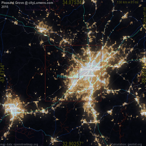
Analysis of Pleasant Grove night lights 2016
Square area 10x10 km:
 11.54%
90-99
11.9%80-89
16.48%70-79
14.29%60-69
15.93%50-59
7.33%40-49
4.58%30-39
6.59%20-29
9.34%10-19
2.01%0-9
0%Square area 50x50 km:
9.44%90-99
7.17%80-89
6.34%70-79
8.05%60-69
7.32%50-59
3.94%40-49
4.28%30-39
4.93%20-29
5.67%10-19
7.78%0-9
35.08%Clear (daylight) street map image can be seen on geolist.org.
Map coordinates:
34° 4' 31.2" North, 87° 40' 24.2" West
33° 29' 27.4" North, 86° 58' 13" West
32° 54' 9.3" North, 86° 16' 1.7" West
Some cities around Pleasant Grove sort by population:
• Birmingham
15.9 km =9.9 mi,  78°
78°
• Hoover
17.5 km =10.9 mi,  122°
122°
• Bessemer
10 km =6.2 mi,  171°
171°
• Homewood
15.9 km =9.9 mi,  97°
97°
• Hueytown
5 km =3.1 mi,  208°
208°
• Fairfield
5.4 km =3.4 mi, 95°
• Forestdale
11.2 km =7 mi,  37°
37°
• Midfield
6.6 km =4.1 mi, 119°
4083846 (p: 10,260)
Sources (retrieved 2019-11-25):
» Earth at Night: Flat Maps 2012, 2016