Hope Mills night lights from space
Night Light of Hope Mills (North Carolina) from space (United States) Src. Average luminocity for 10x10km area is 76.826% and for 50x50km: 32.7109%.
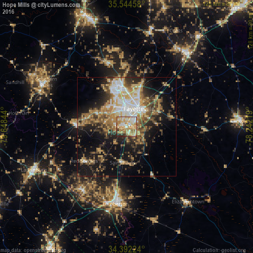
Analysis of Hope Mills night lights 2016
Square area 10x10 km:
 12.27%
90-99
16.85%80-89
21.06%70-79
14.65%60-69
23.26%50-59
1.83%40-49
4.03%30-39
2.56%20-29
3.48%10-19
0%0-9
0%Square area 50x50 km:
4.7%90-99
4.91%80-89
5.32%70-79
4.74%60-69
6.36%50-59
3.9%40-49
4.73%30-39
5.79%20-29
6.47%10-19
16.58%0-9
36.5%Clear (daylight) street map image can be seen on geolist.org.
Map coordinates:
35° 32' 40.5" North, 79° 38' 54.4" West
34° 58' 13.6" North, 78° 56' 43.1" West
34° 23' 32.1" North, 78° 14' 31.9" West
Some cities around Hope Mills sort by population:
• Fayetteville
11 km =6.8 mi,  33°
33°
• Fort Bragg
19.5 km =12.1 mi,  343°
343°
• Lumberton
39.6 km =24.6 mi,  188°
188°
• Laurinburg
52 km =32.3 mi,  245°
245°
• Southern Pines
46.5 km =28.9 mi,  299°
299°
• Spring Lake
22.1 km =13.7 mi,  353°
353°
• Dunn
48.3 km =30 mi,  39°
39°
• Aberdeen
47.6 km =29.6 mi,  292°
292°
4471851 (p: 16,163)
Sources (retrieved 2019-11-25):
» Earth at Night: Flat Maps 2012, 2016