Aberdeen night lights from space
Night Light of Aberdeen (North Carolina) from space (United States) Src. Average luminocity for 10x10km area is 46.6329% and for 50x50km: 10.3606%.
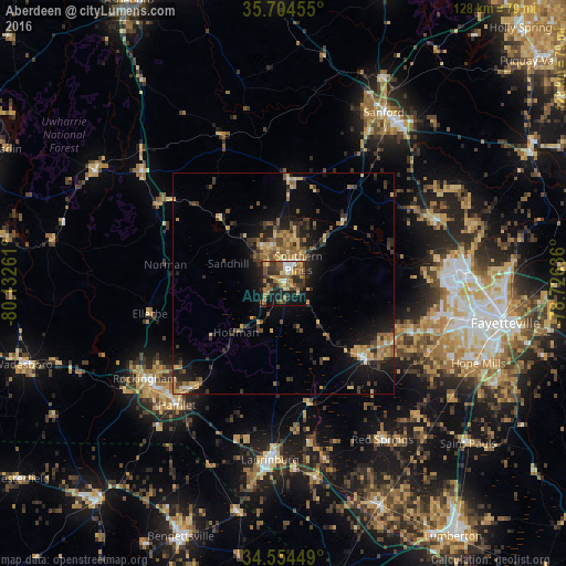
Analysis of Aberdeen night lights 2016
Square area 10x10 km:
 3.67%
3.67%90-99
4.72%80-89
7.17%70-79
9.09%60-69
11.89%50-59
8.57%40-49
5.07%30-39
14.69%20-29
12.24%10-19
20.1%0-9
2.8%Square area 50x50 km:
0.42%90-99
0.47%80-89
1.77%70-79
1.89%60-69
1.89%50-59
1.66%40-49
1.49%30-39
2.85%20-29
2.78%10-19
7.19%0-9
77.57%Clear (daylight) street map image can be seen on geolist.org.
Map coordinates:
35° 42' 16.4" North, 80° 7' 57.4" West
35° 7' 53.6" North, 79° 25' 46.1" West
34° 33' 16.2" North, 78° 43' 34.9" West
Some cities around Aberdeen sort by population:
• Fort Bragg
38.5 km =23.9 mi,  88°
88°
• Sanford
44.8 km =27.8 mi,  30°
30°
• Pinehurst
8 km =5 mi,  332°
332°
• Laurinburg
39.9 km =24.8 mi,  184°
184°
• Southern Pines
5.8 km =3.6 mi,  35°
35°
• Spring Lake
41.7 km =25.9 mi,  84°
84°
• Rockingham
38 km =23.6 mi,  235°
235°
• Hamlet
36.5 km =22.7 mi,  221°
221°
4452137 (p: 7,343)
Sources (retrieved 2019-11-25):
» Earth at Night: Flat Maps 2012, 2016