Southern Pines night lights from space
Night Light of Southern Pines (North Carolina) from space (United States) Src. Average luminocity for 10x10km area is 50.4196% and for 50x50km: 10.5484%.
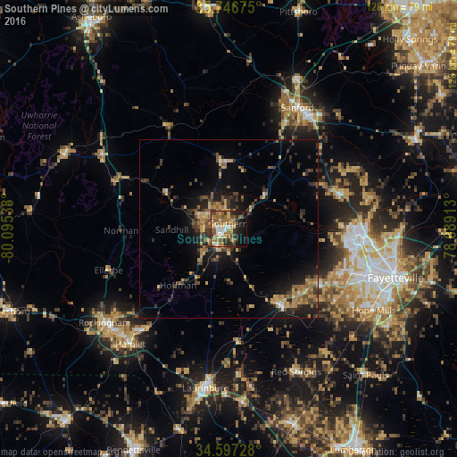
Analysis of Southern Pines night lights 2016
Square area 10x10 km:
 4.2%
4.2%90-99
6.29%80-89
10.66%70-79
5.94%60-69
15.56%50-59
11.89%40-49
6.47%30-39
7.34%20-29
8.57%10-19
18.01%0-9
5.07%Square area 50x50 km:
0.36%90-99
0.46%80-89
1.68%70-79
1.81%60-69
2.08%50-59
1.75%40-49
1.75%30-39
2.93%20-29
2.92%10-19
7.17%0-9
77.1%Clear (daylight) street map image can be seen on geolist.org.
Map coordinates:
35° 44' 48.3" North, 80° 5' 43.4" West
35° 10' 26.6" North, 79° 23' 32.1" West
34° 35' 50.2" North, 78° 41' 20.9" West
Some cities around Southern Pines sort by population:
• Fort Bragg
35.3 km =21.9 mi,  96°
96°
• Sanford
39.1 km =24.3 mi,  29°
29°
• Pinehurst
7.4 km =4.6 mi,  288°
288°
• Laurinburg
44.9 km =27.9 mi,  188°
188°
• Spring Lake
38.1 km =23.7 mi,  91°
91°
• Rockingham
43.5 km =27 mi,  233°
233°
• Aberdeen
5.8 km =3.6 mi,  215°
215°
• Hamlet
42.3 km =26.3 mi, 220°
4492722 (p: 13,539)
Sources (retrieved 2019-11-25):
» Earth at Night: Flat Maps 2012, 2016