Laurinburg night lights from space
Night Light of Laurinburg (North Carolina) from space (United States) Src. Average luminocity for 10x10km area is 46.4267% and for 50x50km: 15.9831%.
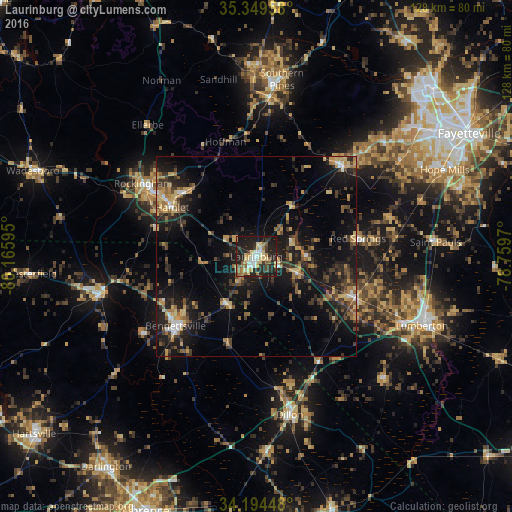
Analysis of Laurinburg night lights 2016
Square area 10x10 km:
 6.04%
6.04%90-99
6.78%80-89
12.09%70-79
4.95%60-69
7.88%50-59
4.03%40-49
2.38%30-39
6.78%20-29
22.34%10-19
26.56%0-9
0.18%Square area 50x50 km:
0.96%90-99
0.84%80-89
2.49%70-79
2.26%60-69
2.47%50-59
1.96%40-49
2.95%30-39
4.32%20-29
5.47%10-19
15.24%0-9
61.05%Clear (daylight) street map image can be seen on geolist.org.
Map coordinates:
35° 20' 58.5" North, 80° 9' 57.4" West
34° 46' 26.6" North, 79° 27' 46.2" West
34° 11' 40.1" North, 78° 45' 34.9" West
Some cities around Laurinburg sort by population:
• Lumberton
44.8 km =27.8 mi,  112°
112°
• Southern Pines
44.9 km =27.9 mi,  8°
8°
• Rockingham
33.8 km =21 mi,  302°
302°
• Bennettsville
26.7 km =16.6 mi,  229°
229°
• Aberdeen
39.9 km =24.8 mi,  4°
4°
• Dillon
40.6 km =25.2 mi,  168°
168°
• Hamlet
24.5 km =15.2 mi, 300°
• Cheraw
39.4 km =24.5 mi,  257°
257°
4475347 (p: 15,507)
Sources (retrieved 2019-11-25):
» Earth at Night: Flat Maps 2012, 2016