Holliston night lights from space
Night Light of Holliston (Massachusetts) from space (United States) Src. Average luminocity for 10x10km area is 25.1848% and for 50x50km: 43.2806%.
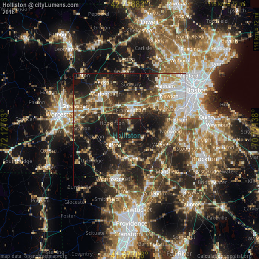
Analysis of Holliston night lights 2016
Square area 10x10 km:
 0.3%
0.3%90-99
1.36%80-89
2.58%70-79
2.27%60-69
1.97%50-59
2.12%40-49
5.91%30-39
5.61%20-29
18.94%10-19
56.82%0-9
2.12%Square area 50x50 km:
5.9%90-99
7.04%80-89
5.61%70-79
5.07%60-69
5.92%50-59
7.28%40-49
8.61%30-39
9.46%20-29
15.91%10-19
20.02%0-9
9.17%Clear (daylight) street map image can be seen on geolist.org.
Map coordinates:
42° 43' 7.8" North, 72° 7' 39.5" West
42° 12' 0.4" North, 71° 25' 28.2" West
41° 40' 37.5" North, 70° 43' 17" West
Some cities around Holliston sort by population:
• Framingham
8.8 km =5.5 mi,  4°
4°
• Framingham Center
10.9 km =6.8 mi,  354°
354°
• Natick
11.1 km =6.9 mi,  33°
33°
• Milford
10.1 km =6.3 mi,  228°
228°
• Ashland
7.5 km =4.7 mi,  334°
334°
• Medway
6.9 km =4.3 mi,  160°
160°
• Millis
6.6 km =4.1 mi,  123°
123°
• Medfield
9.8 km =6.1 mi,  98°
98°
4939693 (p: 14,010)
Sources (retrieved 2019-11-25):
» Earth at Night: Flat Maps 2012, 2016