Medfield night lights from space
Night Light of Medfield (Massachusetts) from space (United States) Src. Average luminocity for 10x10km area is 23.8545% and for 50x50km: 52.6642%.
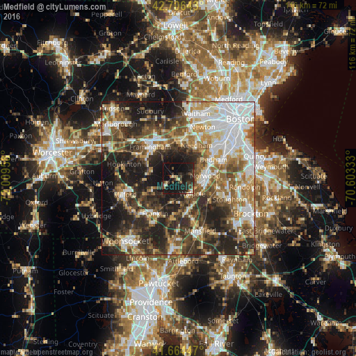
Analysis of Medfield night lights 2016
Square area 10x10 km:
 0.61%
0.61%90-99
2.42%80-89
1.97%70-79
0.76%60-69
2.88%50-59
2.42%40-49
5.15%30-39
6.97%20-29
14.24%10-19
43.18%0-9
19.39%Square area 50x50 km:
11.45%90-99
9.9%80-89
5.91%70-79
5.64%60-69
7.11%50-59
8.29%40-49
9.21%30-39
9.13%20-29
15.73%10-19
14.35%0-9
3.27%Clear (daylight) street map image can be seen on geolist.org.
Map coordinates:
42° 42' 23.1" North, 72° 0' 34.5" West
42° 11' 15.4" North, 71° 18' 23.2" West
41° 39' 52.1" North, 70° 36' 12" West
Some cities around Medfield sort by population:
• Natick
11.2 km =7 mi,  341°
341°
• Norwood
8.8 km =5.5 mi,  84°
84°
• Westwood
7.4 km =4.6 mi,  66°
66°
• Holliston
9.8 km =6.1 mi,  278°
278°
• Medway
9 km =5.6 mi,  235°
235°
• Norfolk
7.7 km =4.8 mi,  191°
191°
• Millis
4.8 km =3 mi, 242°
• Walpole
6.9 km =4.3 mi,  137°
137°
4943616 (p: 6,483)
Sources (retrieved 2019-11-25):
» Earth at Night: Flat Maps 2012, 2016