Hollidaysburg night lights from space
Night Light of Hollidaysburg (Pennsylvania) from space (United States) Src. Average luminocity for 10x10km area is 37.3401% and for 50x50km: 6.2903%.
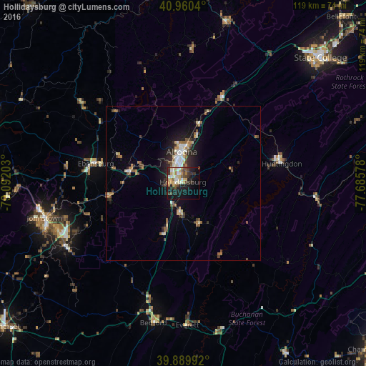
Analysis of Hollidaysburg night lights 2016
Square area 10x10 km:
 5.27%
5.27%90-99
6.46%80-89
6.46%70-79
5.44%60-69
3.4%50-59
3.91%40-49
5.78%30-39
6.97%20-29
10.71%10-19
24.66%0-9
20.92%Square area 50x50 km:
0.72%90-99
0.84%80-89
0.94%70-79
0.54%60-69
0.93%50-59
0.93%40-49
0.82%30-39
0.99%20-29
1.76%10-19
3.82%0-9
87.7%Clear (daylight) street map image can be seen on geolist.org.
Map coordinates:
40° 57' 37.4" North, 79° 5' 31.3" West
40° 25' 38.2" North, 78° 23' 20" West
39° 53' 23.7" North, 77° 41' 8.8" West
Some cities around Hollidaysburg sort by population:
• Altoona
10.2 km =6.3 mi,  357°
357°
• State College
60.4 km =37.5 mi,  47°
47°
• Johnstown
46.5 km =28.9 mi,  256°
256°
• Indiana
68.1 km =42.3 mi,  288°
288°
• Park Forest Village
58 km =36 mi,  43°
43°
• Huntingdon
32.7 km =20.3 mi,  78°
78°
• Clearfield
66.8 km =41.5 mi, 356°
• Tyrone
29.9 km =18.6 mi,  25°
25°
5193920 (p: 5,784)
Sources (retrieved 2019-11-25):
» Earth at Night: Flat Maps 2012, 2016