Clearfield night lights from space
Night Light of Clearfield (Pennsylvania) from space (United States) Src. Average luminocity for 10x10km area is 19.3741% and for 50x50km: 2.0677%.
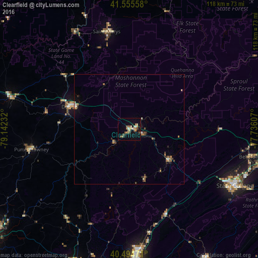
Analysis of Clearfield night lights 2016
Square area 10x10 km:
 1.36%
1.36%90-99
2.72%80-89
1.36%70-79
4.08%60-69
5.1%50-59
2.55%40-49
1.87%30-39
1.19%20-29
2.04%10-19
12.59%0-9
65.14%Square area 50x50 km:
0.11%90-99
0.24%80-89
0.18%70-79
0.39%60-69
0.46%50-59
0.25%40-49
0.29%30-39
0.32%20-29
0.31%10-19
0.86%0-9
96.59%Clear (daylight) street map image can be seen on geolist.org.
Map coordinates:
41° 33' 20.1" North, 79° 8' 32.4" West
41° 1' 38.2" North, 78° 26' 21.1" West
40° 29' 41" North, 77° 44' 9.9" West
Some cities around Clearfield sort by population:
• Altoona
56.7 km =35.2 mi,  176°
176°
• State College
55.2 km =34.3 mi,  118°
118°
• Saint Marys
45.7 km =28.4 mi,  347°
347°
• Shiloh
12.5 km =7.8 mi,  82°
82°
• Park Forest Village
50.3 km =31.3 mi, 119°
• DuBois
28.8 km =17.9 mi,  290°
290°
• Punxsutawney
45.6 km =28.3 mi,  258°
258°
• Tyrone
43.1 km =26.8 mi,  156°
156°
5184541 (p: 6,030)
Sources (retrieved 2019-11-25):
» Earth at Night: Flat Maps 2012, 2016