State College night lights from space
Night Light of State College (Pennsylvania) from space (United States) Src. Average luminocity for 10x10km area is 51.0341% and for 50x50km: 5.7124%.
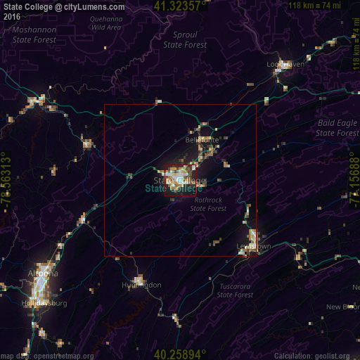

Analysis of State College night lights 2016
Square area 10x10 km:
 9.42%
9.42%90-99
9.09%80-89
6.49%70-79
8.6%60-69
7.95%50-59
5.52%40-49
8.77%30-39
5.68%20-29
14.45%10-19
22.08%0-9
1.95%Square area 50x50 km:
0.52%90-99
0.59%80-89
0.97%70-79
0.59%60-69
0.77%50-59
0.75%40-49
1.05%30-39
1.06%20-29
1.27%10-19
5.27%0-9
87.16%Clear (daylight) street map image can be seen on geolist.org.
Map coordinates:
41° 19' 24.9" North, 78° 33' 47.3" West
40° 47' 36.2" North, 77° 51' 36" West
40° 15' 32.2" North, 77° 9' 24.8" West
Some cities around State College sort by population:
• Altoona
54.5 km =33.9 mi,  235°
235°
• Shiloh
45.6 km =28.3 mi,  307°
307°
• Park Forest Village
5 km =3.1 mi,  287°
287°
• Lock Haven
51.6 km =32.1 mi,  42°
42°
• Lewistown
32.5 km =20.2 mi,  131°
131°
• Huntingdon
36.6 km =22.7 mi,  200°
200°
• Bellefonte
15 km =9.3 mi,  27°
27°
• Tyrone
34.7 km =21.6 mi,  246°
246°
5213681 (p: 42,161)
Sources (retrieved 2019-11-25):
» Earth at Night: Flat Maps 2012, 2016