Indiana night lights from space
Night Light of Indiana (Pennsylvania) from space (United States) Src. Average luminocity for 10x10km area is 32.9951% and for 50x50km: 3.5499%.
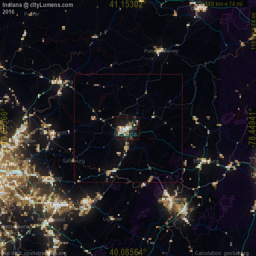
Analysis of Indiana night lights 2016
Square area 10x10 km:
 5.19%
5.19%90-99
6.01%80-89
2.27%70-79
2.92%60-69
6.01%50-59
6.33%40-49
3.73%30-39
3.08%20-29
5.52%10-19
38.31%0-9
20.62%Square area 50x50 km:
0.29%90-99
0.37%80-89
0.31%70-79
0.4%60-69
0.63%50-59
0.67%40-49
0.5%30-39
0.55%20-29
0.86%10-19
2.54%0-9
92.89%Clear (daylight) street map image can be seen on geolist.org.
Map coordinates:
41° 9' 10.9" North, 79° 51' 20.4" West
40° 37' 17.3" North, 79° 9' 9.1" West
40° 5' 8.3" North, 78° 26' 57.9" West
Some cities around Indiana sort by population:
• Murrysville
50.8 km =31.6 mi,  245°
245°
• Johnstown
38.1 km =23.7 mi,  149°
149°
• Greensburg
48.3 km =30 mi,  222°
222°
• Lower Burrell
51.6 km =32.1 mi,  261°
261°
• Jeannette
51 km =31.7 mi,  230°
230°
• Latrobe
38.5 km =23.9 mi,  209°
209°
• Punxsutawney
39 km =24.2 mi,  23°
23°
• Vandergrift
34.9 km =21.7 mi,  266°
266°
5194868 (p: 14,100)
Sources (retrieved 2019-11-25):
» Earth at Night: Flat Maps 2012, 2016