Spencer night lights from space
Night Light of Spencer (Massachusetts) from space (United States) Src. Average luminocity for 10x10km area is 12.453% and for 50x50km: 15.9148%.
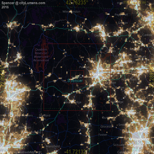
Analysis of Spencer night lights 2016
Square area 10x10 km:
 0.15%
0.15%90-99
1.67%80-89
2.42%70-79
0.91%60-69
1.52%50-59
1.52%40-49
2.88%30-39
0.61%20-29
2.12%10-19
1.36%0-9
84.85%Square area 50x50 km:
2%90-99
2.47%80-89
2.23%70-79
1.95%60-69
2.67%50-59
2.37%40-49
1.93%30-39
2.23%20-29
4.21%10-19
9.63%0-9
68.31%Clear (daylight) street map image can be seen on geolist.org.
Map coordinates:
42° 45' 44.5" North, 72° 41' 43.5" West
42° 14' 38.3" North, 71° 59' 32.3" West
41° 43' 16.8" North, 71° 17' 21" West
Some cities around Spencer sort by population:
• Worcester
15.8 km =9.8 mi,  82°
82°
• Southbridge
19.1 km =11.9 mi,  190°
190°
• Holden
16 km =9.9 mi,  41°
41°
• Auburn
14 km =8.7 mi,  113°
113°
• Charlton
12.2 km =7.6 mi,  171°
171°
• Leicester
6.9 km =4.3 mi,  88°
88°
• Hamilton Worcester
18.5 km =11.5 mi, 85°
• Oxford
17.6 km =10.9 mi,  143°
143°
4951699 (p: 5,700)
Sources (retrieved 2019-11-25):
» Earth at Night: Flat Maps 2012, 2016