Helena Valley Southeast night lights from space
Night Light of Helena Valley Southeast (Montana) from space (United States) Src. Average luminocity for 10x10km area is 17.5327% and for 50x50km: 2.5132%.
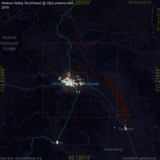
Analysis of Helena Valley Southeast night lights 2016
Square area 10x10 km:
 0.99%
0.99%90-99
2.41%80-89
0.28%70-79
2.13%60-69
3.41%50-59
3.98%40-49
3.13%30-39
2.56%20-29
6.11%10-19
20.03%0-9
54.97%Square area 50x50 km:
0.36%90-99
0.46%80-89
0.15%70-79
0.3%60-69
0.33%50-59
0.25%40-49
0.33%30-39
0.23%20-29
0.77%10-19
2.54%0-9
94.27%Clear (daylight) street map image can be seen on geolist.org.
Map coordinates:
47° 5' 45.9" North, 112° 37' 28.9" West
46° 36' 55" North, 111° 55' 17.6" West
46° 7' 48.5" North, 111° 13' 6.4" West
Some cities around Helena Valley Southeast sort by population:
• Missoula
160.5 km =99.7 mi,  280°
280°
• Great Falls
109.1 km =67.8 mi,  25°
25°
• Bozeman
124.3 km =77.2 mi,  146°
146°
• Butte
82.7 km =51.4 mi,  214°
214°
• Butte-Silver Bow (Balance)
97.4 km =60.5 mi,  215°
215°
• Anaconda
95.2 km =59.2 mi,  235°
235°
• Belgrade
109.5 km =68 mi, 148°
• Livingston
149 km =92.6 mi,  135°
135°
7261423 (p: 8,227)
Sources (retrieved 2019-11-25):
» Earth at Night: Flat Maps 2012, 2016