Saint John night lights from space
Night Light of Saint John (Missouri) from space (United States) Src. Average luminocity for 10x10km area is 96.818% and for 50x50km: 66.5729%.
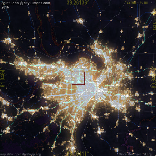
Analysis of Saint John night lights 2016
Square area 10x10 km:
 41.67%
90-99
45.75%80-89
11.9%70-79
0.68%60-69
0%50-59
0%40-49
0%30-39
0%20-29
0%10-19
0%0-9
0%Square area 50x50 km:
19.42%90-99
16.3%80-89
9.21%70-79
11.84%60-69
9.3%50-59
5.68%40-49
3.73%30-39
4.16%20-29
6.62%10-19
4.6%0-9
9.14%Clear (daylight) street map image can be seen on geolist.org.
Map coordinates:
39° 15' 40.9" North, 91° 2' 57.8" West
38° 42' 53.4" North, 90° 20' 46.6" West
38° 9' 50.8" North, 89° 38' 35.3" West
Some cities around Saint John sort by population:
• University City
7.3 km =4.5 mi,  153°
153°
• Maryland Heights
7.3 km =4.5 mi,  268°
268°
• Hazelwood
6.6 km =4.1 mi,  341°
341°
• Ferguson
4.8 km =3 mi,  47°
47°
• Overland
2.1 km =1.3 mi,  222°
222°
• Berkeley
4.6 km =2.9 mi,  16°
16°
• Olivette
6.1 km =3.8 mi,  205°
205°
• Dellwood
6.5 km =4 mi, 53°
4406941 (p: 6,584)
Sources (retrieved 2019-11-25):
» Earth at Night: Flat Maps 2012, 2016