Bridgeton night lights from space
Night Light of Bridgeton (Missouri) from space (United States) Src. Average luminocity for 10x10km area is 89.0799% and for 50x50km: 57.6216%.
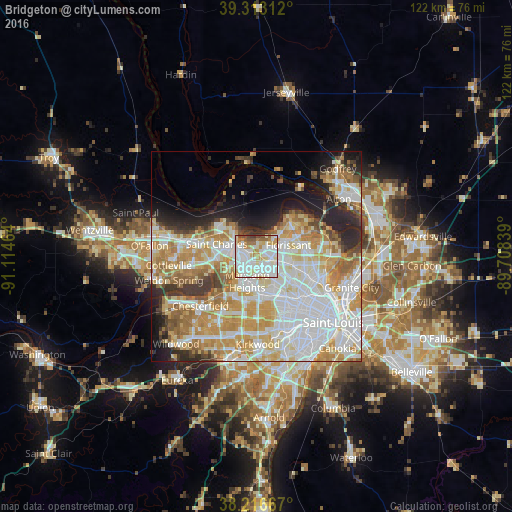
Analysis of Bridgeton night lights 2016
Square area 10x10 km:
 34.35%
90-99
31.8%80-89
10.37%70-79
8.16%60-69
6.97%50-59
4.93%40-49
2.72%30-39
0.68%20-29
0%10-19
0%0-9
0%Square area 50x50 km:
17.51%90-99
13.63%80-89
8.11%70-79
10.19%60-69
7.3%50-59
4.12%40-49
2.87%30-39
3.87%20-29
6.52%10-19
6.37%0-9
19.52%Clear (daylight) street map image can be seen on geolist.org.
Map coordinates:
39° 18' 47.2" North, 91° 6' 52.7" West
38° 46' 1.2" North, 90° 24' 41.4" West
38° 13' 0" North, 89° 42' 30.2" West
Some cities around Bridgeton sort by population:
• Saint Charles
6.3 km =3.9 mi,  287°
287°
• Florissant
8.1 km =5 mi,  72°
72°
• Maryland Heights
6.2 km =3.9 mi,  194°
194°
• Hazelwood
3.6 km =2.2 mi,  82°
82°
• Saint Ann
5.1 km =3.2 mi,  150°
150°
• Berkeley
7.1 km =4.4 mi,  101°
101°
• Saint Johns
8.4 km =5.2 mi,  135°
135°
• Saint John
8.1 km =5 mi, 135°
4378391 (p: 11,786)
Sources (retrieved 2019-11-25):
» Earth at Night: Flat Maps 2012, 2016